

Flood and Drought hazards are one of the most significant factors affecting poverty reduction measures and economic development in Cambodia.Our works is focusing on providing a conceptual framework or national architecture for flood and drought forecasting in related to the hydro-meteorological network designed system. The conceptual framework presents the fundamental flood&drought forecasting and hydro-met station design based on field survey to defined instrumentation, data processing, and data management.

“Assessment of Hydrology for Agricultural Development Based one Climate Change in Prek Thnot
September 30, 2015
This study was to coup up with the Cambodian Government’s Policy on technical information for agricultural development in Prek Thnot River Basin, which can shares with relevant ministries (Ministry of Water Resource and Meteorology, Ministry of Agriculture, Forestry and Fisheries (MAFF), Ministry of Environment (MoE) and other related agencies). This can help to strengthen knowledge for Development Partner on application of hydrological modeling and provide a clear technical information on water resources development bases on climate change, landuse change and upstream dam development
Hydrology and Meteorology Works
June 06, 2017
-
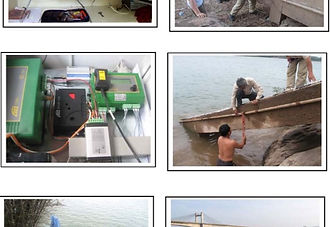
Site Survey and Design Station for Hydro-met network Installation,
-
Procurement Material needed for installation and clearances,
-
Construction Work of Water Level and Rain Gauge Stations,
-
Data Management and Analyses
-
Materials, spare-parts and equipment supply

Irrigation System Construction & Installation
July 26, 2017
GESC employs designers, project managers, irrigation specialists and electricians to keep the use of sub-contractors to a minimum. Utilizing computer-aided design software and GPS mapping, precision and accuracy is maintained through the design process. Precise designs require fewer in-field modifications; minimizing installation time. Our installation crews are both knowledgeable and experienced in their field.
In order to have the most flexibility to meet your installation time frame, we own various types of excavation equipment, trenchers, tractors, crane trucks, pump rigs and service equipment.

The Hydro-Meteorological Network at Regional Level (MRC)
June 30, 2017
We had experiences with the Mekong River Commission (MRC) in cooperation with the World Meteorological Organization (WMO) for establishing a near-real time Hydro-meteorological network for the four Mekong member countries (Cambodia, Lao PDR, Thailand and Veitnam), named as the Mekong-Hydro-Cycle Observating System (Mekong-HYCOS). It was funded by the French Development Agency (AFD).
The main objective of this hydro-meteorological network was to establish an efficient, reliable and timely hydro-meteorological data collection and transmission system. The project also cooperateed with China by sharing hydro-meteorological data from two upstream Mekong stations at Jinghong and Man’an. This MRC hydro-meteorological network is a basin-wide hydro-meteorological information system, which covers the Mekong mainstream and its main tributaries. The system has integrated into the existing MRCS monitoring system. It has also improved the national hydrological networks and river monitoring / forecasting capacities.
49 network stations provide near real-time water level and rainfall data at 15 min time step intervals for the Mekong mainstream and its main tributaries as depicted in Fig. 1. Online charts from the stations are available at: http://monitoring.mrcmekong.org/

Project Management and Others
January 01, 2020
The organization and management of the project is based on the concept that the participating countries (Cambodia, Lao PDR, Thailand and Vietnam) have full ownership of the project and will have primary responsibility for the implementation of the project through their concerned line agencies in coordination with the National Mekong Committees.

